GIS Map of India

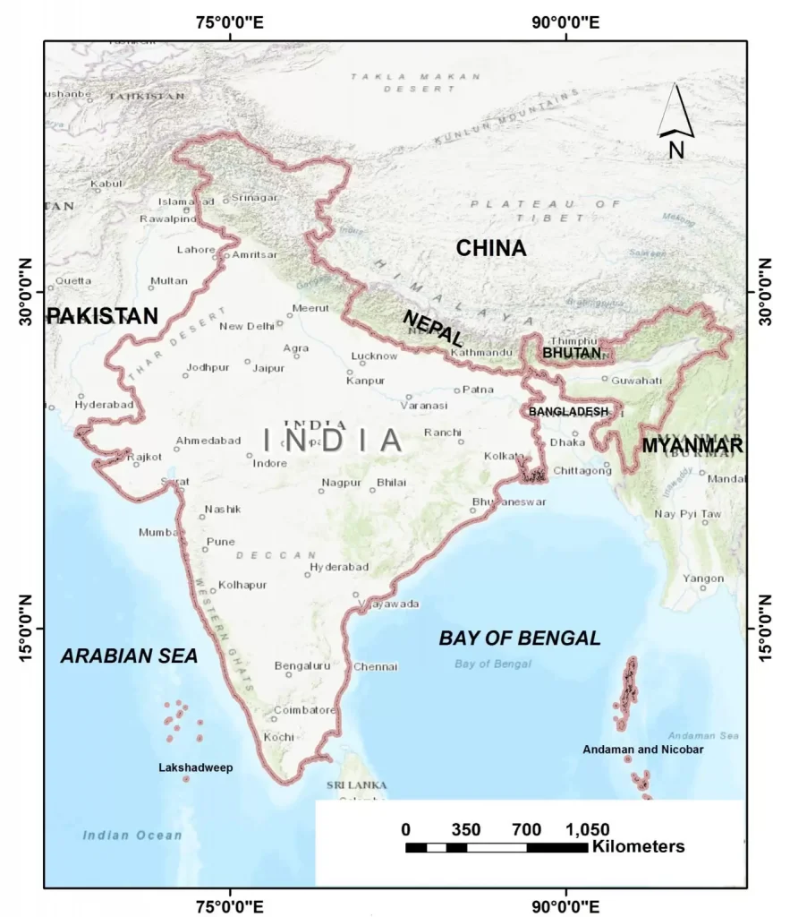
India is a country in South Asia. It is the seventh-largest country by area, the second-most populous country, and the most populous democracy in the world. Bounded by the Indian Ocean on the south, the Arabian Sea on the southwest, and the Bay of Bengal on the southeast, it shares land borders with Pakistan to the west, China, Nepal, and Bhutan to the northeast, and Bangladesh and Myanmar to the east. In the Indian Ocean, India is in the vicinity of Sri Lanka and the Maldives, its Andaman and Nicobar Islands share a maritime border with Thailand and Indonesia.
India States
- Andhra Pradesh
- Arunachal Pradesh
- Assam
- Bihar
- Chhattisgarh
- Goa
- Gujarat
- Haryana
- Himachal Pradesh
- Jammu and Kashmir
- Jharkhand
- Karnataka
- Kerala
- Madhya Pradesh
- Maharashtra
- Manipur
- Meghalaya
- Mizoram
- Nagaland
- Odisha
- Punjab
- Rajasthan
- Sikkim
- Tamil Nadu
- Telangana
- Tripura
- Uttar Pradesh
- Uttarakhand
- West Bengal
Union Territories
- Andaman and Nicobar Islands
- Chandigarh
- Dadra and Nagar Haveli
- Daman and Diu
- Lakshadweep
- Puducherry
- National Capital Territory of Delhi
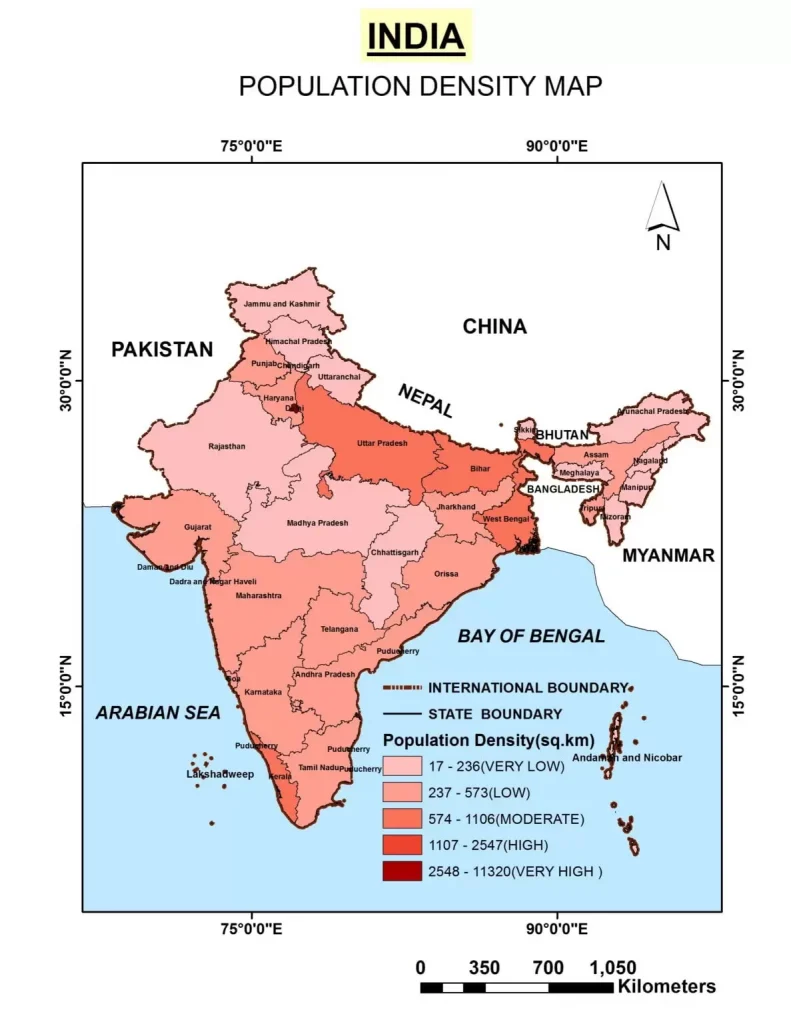
State wise Population Density
India Population Density- 382/km2 (census 2011)
- Andhra Pradesh – 303/km2
- Arunachal Pradesh – 17/km2
- Assam – 397/km2
- Bihar – 1,102/km2
- Chhattisgarh – 189/km2
- Goa – 394/km2
- Gujarat – 308/km2
- Haryana – 573/km2
- Himachal Pradesh – 123/km2
- Jammu and Kashmir – 57/km2
- Jharkhand – 414/km2
- Karnataka – 319/km2
- Kerala – 859/km2
- Madhya Pradesh – 236/km2
- Maharashtra – 365/km2
- Manipur – 122/km2
- Meghalaya- 132/km2
- Mizoram – 52/km2
- Nagaland – 119/km2
- Odisha – 269/km2
- Punjab – 550/km2
- Rajasthan – 201/km2
- Sikkim – 86/km2
- Tamil Nadu – 555/km2
- Telangana – 312/km2
- Tripura – 350/km2
- Uttar Pradesh- 828/km2
- Uttarakhand – 189/km2
- West Bengal – 1,029/km2
- NCT Delhi – 11,297/km2
- Andaman and Nicobar Islands – 46/km2
- Chandigarh – 9,252/km2
- Dadra and Nagar Haveli – 698/km2
- Daman and Diu – 2,169/km2
- Lakshadweep – 2,013/km2
- Puducherry – 2,598/km2

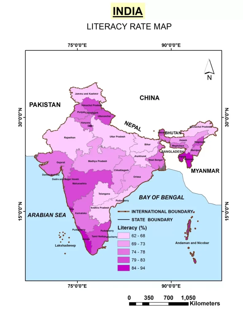
State wise Literacy Rate
India Literacy Rate- 74.04 (census 2011)
- Kerala 93.91
- Lakshadweep 91.28
- Mizoram 91.58
- Tripura 87.75
- Goa 87.40
- Daman and Diu 87.07
- Puducherry 86.55
- Chandigarh 86.43
- Andaman and Nicobar Islands 86.27
- Delhi 86.34
- Himachal Pradesh 83.78
- Maharashtra 82.91
- Sikkim 82.20
- Tamil Nadu 80.33
- Nagaland 80.11
- Manipur 79.85
- Uttarakhand 79.63
- Gujarat 79.31
- Dadra and Nagar Haveli 77.65
- West Bengal 77.08
- Punjab 76.68
- Haryana 76.64
- Karnataka 75.60
- Meghalaya 75.48
- Odisha 73.45
- Assam 73.18
- Chhattisgarh 71.04
- Madhya Pradesh 70.63
- Uttar Pradesh 69.72
- Jammu and Kashmir 68.74
- Jharkhand 67.63
- Andhra Pradesh 67.35
- Rajasthan 67.06
- Arunachal Pradesh 66.95
- Telangana 66.5
- Bihar 63.82

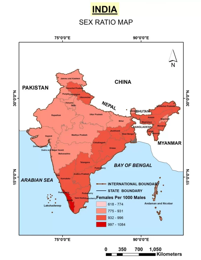
State wise Sex Ratio
India Sex ratio- 943 , Child Sex ratio- 919 (census 2011)
Sex Ratio . Child Sex Ratio
- Kerala – 1084 – 966
- Puducherry – 1037 – 967
- Tamil Nadu – 996 – 943
- Andhra Pradesh – 993 – 939
- Chhattisgarh – 991 – 960
- Meghalaya – 989 – 970
- Manipur – 987 – 930
- Telangana – 985
- Odisha – 979 – 941
- Mizoram – 976 – 970
- Goa – 973 – 942
- Karnataka – 973 – 948
- Himachal Pradesh – 972 – 909
- Uttarakhand – 963 – 890
- Tripura – 960 – 957
- Assam – 958 – 962
- West Bengal – 950 – 956
- Jharkhand – 948 – 948
- Lakshadweep – 946- 911
- Arunachal Pradesh – 938 – 972
- Nagaland – 931 – 943
- Madhya Pradesh – 931 – 918
- Maharashtra – 929 – 894
- Rajasthan – 928 – 888
- Gujarat – 919 – 890
- Bihar – 918 – 935
- Uttar Pradesh – 912 – 902
- Punjab – 895 – 846
- Sikkim – 890 – 957
- Jammu and Kashmir – 889 – 862
- Haryana – 879 – 834
- Andaman and Nicobar Islands – 876 – 968
- Delhi – 868 – 871
- Chandigarh – 818 – 880
- Dadra and Nagar Haveli – 774 – 926
- Daman and Diu – 618 – 904

